... earthquake 23 December 2011 ...
sponsored by:
Sponsor Logo
space for lease

|
... earthquake 23 December 2011 ... |
sponsored by: |
Sponsor Logo |

|
|
Christchurch [N.B. Page under construction]: [Back to] 4 September 2010 or 22 February 2011 or 13 June 2011 InfoHelp earthquake page Recap Christchurch earthquake indexing: #1. 04 September 2010 - magnitude 7.1 #2. 22 February 2011 - magnitude 6.3 #3. 13 June 2011 - magnitude 6.3 Christchurch earthquake watch warning was issued 17 December 2011 #4. 23 December 2011 - magnitude 6.0 - this page #5. Kaiapoi fault? - new-old fault larger? Plenty of signal evidence of the impending qauke was available, but no wonder it came as a shock when this is the official attitude: Christchurch authorities kick in quake response "Earthquake Recovery Minister Gerry Brownlee.. said that before today's aftershocks, he had started to relax and so the series of terrifying earthquakes took him by surprise.. less damage than that created on June 13.. 'We're still within the decay curve, that we've published and republished a number of times over the last few months, and so there was a probability that we could have one of these - it was a low probability.' The Minister said geotechnical officials reckon the damage today is 30% or 40% of what was caused by June's major aftershock. 'The fact that we've had it gets it out of the way so let's look at the bright side - the damage hasn't been as extensive as some of the other events,' he said." tvnz.co.nz/national-news 23 Dec 2011 "Pattern of quakes likely to continue: Kelvin Berryman of GNS Science told Summer Report the quakes on Friday were a similar pattern to those in February and June. He said this is likely to continue but areas which have been closest to the quakes so far may not be the centre for future events." Land assessment needed after quakes, says mayor radionz.co.nz 27 Dec 2011 + Mayor admits failings over handling of Sept quake 2 Jan 2012 + Quake swarm rattles Christchurch stuff.co.nz The 17 December watch warning blog entry details all the Kermadec trench movement coincident with this new event, that pounded added energy in for it (e.g. long double-blips matched on each set of six charts below). Steady grumblings on all the local seismometers thereafter were sure giveaways - with a two large local quakes recorded in the Waitaha Valley: 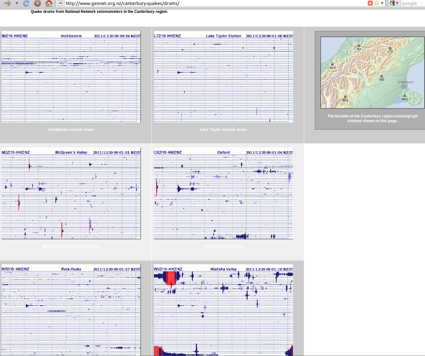 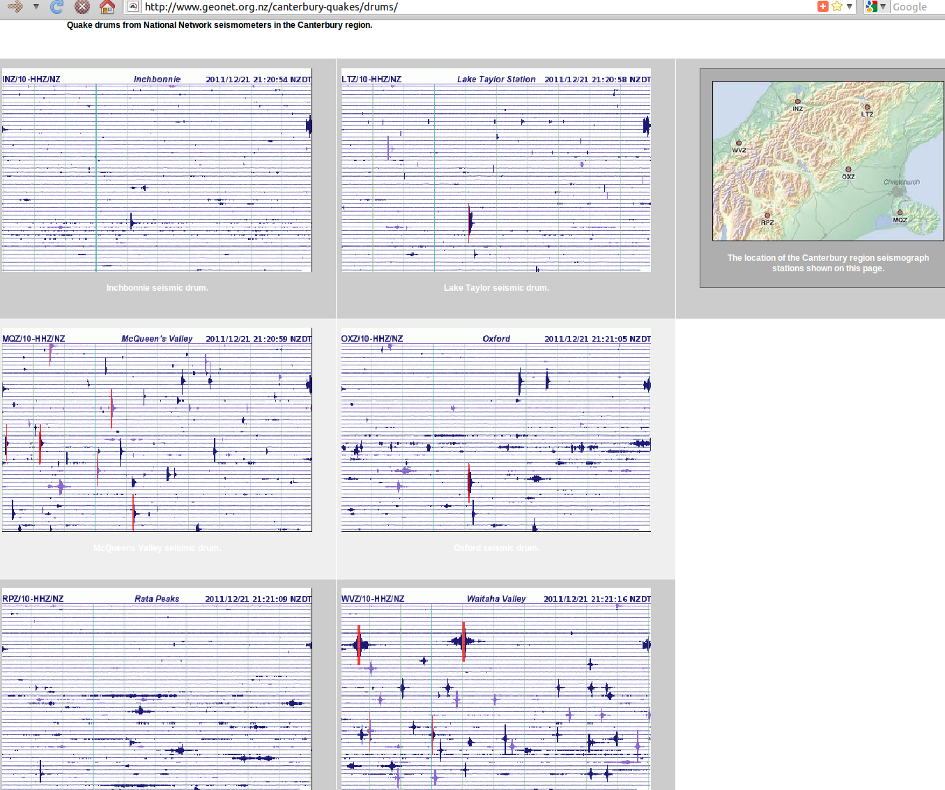 Source: geonet.org.nz/canterbury-quakes/drums Big pressures had been thundering around the Pacific Rim beforehand: 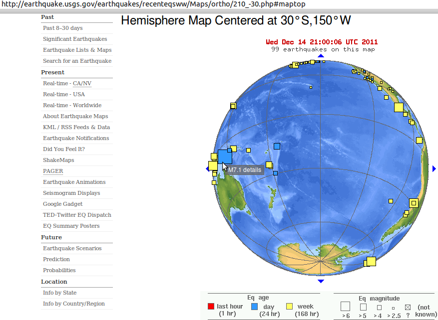 Source: earthquake.usgs.gov/earthquakes/recenteqsww/Maps/ortho/ Alpine fault 'biggest risk' "to South Canterbury, despite the possibility of other unknown faults in the area, Otago University geologists say. Saturday's 7.1 magnitude earthquake near Darfield on a previously unknown fault caught geologists by surprise and indicated that they did not know where all the faults were, Otago lecturer Dr Virginia Toy told the Timaru Herald. Though Dr Toy and fellow Otago University geologist Professor Richard Norris would not rule out an unknown fault in South Canterbury, the Alpine Fault was considered the region's most likely source of a large-scale quake in the next 50 years. 'I can't guarantee it won't [happen] but the statistical probability is a lot less for the Alpine fault going,' Dr Toy said. Every year there was a 1 per cent chance of an Alpine Fault earthquake and there was a 50 per cent chance of an earthquake happening in the next 50 years. The Alpine fault had generated a 7.9 earthquake in the past and could produce an earthquake up to 8 magnitude, she said. She doubted Saturday's quake would have the ability to generate a quake on the Alpine Fault but it could be the first in a series of large quakes. Prof Norris said the Alpine fault accounted for the release of 70 per cent of seismic strain in the South Island. The other 30 per cent - worked out to be approximately 40 quakes over a 1000-year period, equating to about one quake every 25 years - came from faults on the eastern side of the island, some of which were known, and some which were not, he said. 'There's probably quite a few potential faults to the west of Timaru.' Prof Norris said there was a possibility more large earth quakes could occur in a short period of time. A group of large earthquakes occurred in the middle of the 19th century, then again in the 1920s and 30s, he said. 'In a way it's quite salutary this has happened in Christchurch.' The emergency services had been very well prepared and the city had come through the event, he said. While the city had a much lower statistical risk of earthquake than Wellington, quakes could be expected anywhere in the country. 'Everywhere in New Zealand is earthquake prone. The islands exist because of earthquakes.'" Timaru Herald 07/09/2010 Boffins probe alpine quake fault "By drilling into the fault zone scientists hope to get an accurate picture of the chemical and physical conditions inside a major active fault. It is the first deep drilling investigation at a major active New Zealand fault.. The researchers plan a much deeper borehole - possibly to 1500m - in the future, but the exact location is yet to be determined. Project leader Dr Rupert Sutherland said there was considerable international interest in the project because it had the potential to answer a number of important questions about plate boundary earthquakes and the evolution of large faults. 'There are many unknowns about what takes place at a fault interface before and during an earthquake. The fundamental question of what conditions cause an earthquake to start is yet to be answered,' he said. The fault, whose effects are visible from space, extends for more than 650km, from south of Fiordland along the western spine of the Southern Alps and into Marlborough. Geological evidence suggests it ruptures every 200 to 400 years, producing earthquakes that cause strong shaking throughout much of the South Island. Scientists believe it last ruptured in 1717" The Press 23/01/2011 + prescient Quake prediction 'like a horoscope' one month out re mag 6.3 22 February 2011 Marlborough Express 18/02/2011 + ... The Christchurch Earthquake: tectonic plates and fault lines Lincoln Prof Keith Woodford blog 7Mar11 + Ask an Expert: Alpine Fault fears Q: "When the Alpine Fault goes, and, surmising it is a sub-8 rupture, what would the effect be on buildings and soil in Christchurch? Would it trigger faults to rupture here? - Luke [A:] The best estimate for the rupture of the southern and central section of the Alpine fault (from south of Milford Sound to around Inchbonnie), which appears to have been the extent of past ruptures, is estimated to be near to a magnitude 8 earthquake. The effects of such an earthquake have been discussed for many years. The consensus is that the strength of shaking would be much less than has been experienced in the recent Canterbury sequence (because of the 100km distance between the fault and Christchurch), but, because of the much larger magnitude, the low-level shaking would probably go on for a long time and could be expected to last for four to five minutes for an Alpine Fault quake. This would very likely induce widespread liquefaction in susceptible sediments (and was taken into account in recent government decisions about retreating from the most susceptible suburbs). The impact of such an earthquake on well-engineered buildings would not be a problem. The earthquake and its shaking characteristics are incorporated into building code requirements. - Dr Kelvin Berryman, manager, Natural Hazards Research Platform, GNS Science" The Press 06/07/2011 + ... Greendale fault still under stress "Aftershock activity moving back to the west of Christchurch is a sign stress still needs to be released from near the Greendale Fault, scientists say.." The Press 24/01/2012 Threat of quake in Southern Alps wanes "the Alpine Fault could still be 200 years away from generating its next quake of about magnitude 8.0. Scientists have found that the most active central and southern sections of the 650-kilometre-long fault appear to break on average once every 480 years, not about every 300 years as previous studies suggested" The Press 2/04/12; then 11/04/12 Pacific Plate upsurge: Indonesia 8.6, Oregon 6, Mexico 7, Westport, Christchurch quakes hours apart "A magnitude 4.0 quake has struck Westport, after a 4.6 quake rocked Christchurch" + NZ's quake risk 'difficult to assess' "New Zealand's historical record is too short to be able to gauge the risk of it being hit by massive quakes the size of those that struck off the west coast of northern Sumatra last night. The main quake at 8.38pm (NZT) had a magnitude of 8.6. An 8.2-magnitude quake followed at 10.43pm and there have been numerous aftershocks of magnitude-5.0 or greater" 12/04/2012 + Alpine quake optimism faulted by geologists "The best approach was to accept the fault's next major quake could occur any time and to be prepared for that" 13/04/2012 + Slowing-moving quakes last 30 minutes "deep beneath the Alpine Fault on the South Island's West Coast, regarded as New Zealand's most hazardous faultline.. central section.. between Fox Glacier and Whataroa Valley 50 kilometres to the north.. strike-slip fault.. other was the San Andreas Fault in California.. Southern Alps Microearthquake Borehole Array, or Samba, was installed in late 2009.. has recorded about 2500 small quakes that are taking place in a 30km-wide area under the Southern Alps, rather than on the Alpine Fault" 22/05/2012 + Scientists' positive spin on fault lines little comfort "Scientists looking at 21 months of seismic movement, including the September 2010 and February, June and December 2011 quakes, said the direction of the stress field across the region had not changed as a result of all that activity. Pennsylvania State University seismologist Professor Kevin Furlong, who spent several months at Canterbury University during the quakes, said that was a 'comforting thing'. A change in stress direction might have meant more faults rupturing. Mark said on press.co.nz: 'I'm a man of science but colour me pessimistic when the field of expertise of seismology is dictated by statements that start with 'We think' and 'Expect' and 'Maybe'.'" 22/06/2012 + Big one could isolate capital for four months & Map plots quakes from 1898 "Shows how quake-prone NZ and Pacific Rim are" 05/07/2012 + Last Alpine Fault quake size revised "8.1.. the great 1717 quake's magnitude, which is plus or minus 0.1 of magnitude because of uncertainties in the fault's precise shape.. liquefaction would likely be extensive in known liquefaction-prone areas of Canterbury" 14/07/2012 + Post-quake preparedness a priority for town "geologists are not even sure which direction the Alpine Fault normally does break" 28/07/2012 + Are huge earthquakes linked? " Two of the six largest quakes since 1900 - the magnitude-8.8 shake that rocked Chile in February 2010, and the 9.0 quake that slammed Japan in March 2011 - occurred just 13 months apart. What's more, a group of four major shocks around the Pacific Rim in the early 1960s occurred within the span of 57 months. Coincidence? Probably, say researchers who analysed the spacing of quakes with a magnitude of 8.3 or greater that occurred from 1900 through 2011. The chance of two such quakes occurring within 1 year of each other was 9.5 per cent, the researchers report in the Bulletin of the Seismological Society of America. That's about the same chance of duplicating any particular arrangement of quakes, the researchers said - even a pattern with widely scattered shocks that isn't particularly remarkable. After comparing the actual pattern of quakes in the past 111 years with hundreds of patterns generated by three different statistical distributions, the team said there was no compelling evidence that major quakes were linked. So next time a big quake happens somewhere in the world, rest easy: It doesn't bode ill for your local fault zone." 3Aug12 + What If... events 100 million years ago controlled the Canterbury earthquake sequence? Dr Martin Reyners, Principal Scientist at GNS Science, Lower Hutt, at Uni of Canterbury 4Oct12 youtube + ... Alpine Fault quake risk 'increasing' "Christchurch City Council hosted a community forum on Saturday on the risks the city and the region face from natural hazards like earthquakes, floods and tsunamis. Hazards analyst Peter Kingsbury said while the region is heading into a period of reduced seismicity of faults near the city, quakes centred in the Southern Alps are an increasing risk. He said climate change and the extreme weather events it creates will remain a thorn in Christchurch's side" RadioNZ 15Mar2014 & Flood risk beats Canterbury quake risk "Canterbury Civil Defence controller Neville Reilly says flooding is still the biggest threat to the region despite a predicted 65 percent chance of the Alpine Fault rupturing in the next 50 years. The regional Civil Defence Emergency Management Group, made up of mayors from the regions' councils, is finalising its plan for how to manage the areas' hazards. Mr Reilly said the threat from the Alpine Fault had long been known but there was now more research into its likely impact. He said if the Alpine Fault went it wouldn't be as damaging to Christchurch as the recent more localised earthquakes. Mr Reilly said the Mackenzie District was the area most at risk from the Alpine Fault rupturing" 30May14 + Ten by Ten: How do our tectonic plates lock together? Dr Martin Reyners to Royal Society of NZ 7Aug14 vimeo + ... The Next Alpine Fault Earthquake in New Zealand GNS Science youtube 27Mar15 * * * * * When, not if: Alpine fault could cause 8 metres of movement stuff.co.nz/science 6Apr15 + Alpine Fault spreads across South Island, researchers say 2Sep15 & Alpine Fault bigger than thought - researcher RadioNZ + ... Alpine Fault moves more than any other known land fault in the world "In the past 25 million years, the two sides of the South Island have shifted more than 700 kilometres relative to each other along the Alpine Fault. That is 250km more than previously thought. The full extent of the movement was masked because the rocks first moved 250km in one direction, then went back the other way - retracing the first 250km and adding a further 450km.. average speed of about 3cm a year" stuff.co.nz/science 8Mar16 'Slow slips' could trigger big quakes "or alleviate - large, tsunami-generating earthquakes" RadioNZ 6May16 & Investigating slow slip earthquakes with HOBITTS The Hikurangi Ocean Bottom Investigation of Tremor and Slow Slip 18May16 San Andreas fault 'locked, loaded and ready to roll' with big earthquake, expert says "it's important that California focus on becoming resilient to a potential huge earthquake, one as strong as a magnitude 8" Los Angeles Times via Stuff 5May16 Are we ready? What to expect when the Alpine Fault ruptures "a 30 per cent chance of a large earthquake on the Alpine Fault in the next 50 years. It could cause horizontal movement of up to eight metres" Stuff 21May16 Major Alpine Fault quake could severely damage Canterbury - research "Brendon Bradley, professor in earthquake engineering at the University of Canterbury, has created a computer simulation of the likely impact of a magnitude 8 earthquake on the Alpine Fault" RNZ 25May16 Environment Southland receives $245k grant for Alpine Fault research Stuff 22Jun16 Team granted funding to plan response for Alpine Fault megaquake "with the potential to 'unzip' the South Island happens roughly every 300 years - the last one was in 1717. The Government has put together a team of scientists and civil defence experts to investigate the possible 8.0 magnitude quake, which could tear chasms in the ground, cause landslides, damage state highways and topple cellphone towers. The Ministry of Civil Defence and Emergency Management has granted them $490,000 to create a high-level response plan within two years.. Alpine Fault is expected to 'unzip' from Milford Sound to Hokitika.. the longer it took, the worse it would be as pressure built beneath the Earth's surface.. Response efforts would likely be co-ordinated from Marlborough as the main access point between the North and South Island, with agencies from across the country working from the Emergency Operations Centre in Blenheim" Stuff 27Jul16 Queenstown conference told of potential impact of alpine fault rupture "Project AF8 [Alpine Fault Magnitude 8], a group set up to 'collectively plan for an Alpine Fault event.. When the Alpine Fault pops, there won't be a Milford Sound anymore'.. The central and southern parts of the Alpine Fault run for about 400 kilometres up the spine of the South Island, and are about 40 times longer than the fault responsible for the fatal February 2011 earthquake in Christchurch. GNS science said in May there was a 30 per cent chance of a large earthquake on the Alpine Fault in the next 50 years, which could cause horizontal movement of up to eight metres" Stuff 14Oct16 + Rural GP reflects on training reality check in Christchurch earthquake 19Oct16 New study says Alpine Fault quake interval shorter than thought: GNS Science "The Alpine Fault runs for about 600km along the spine of the South Island.. last ruptured three hundred years ago in 1717, shaking the South Island at an intensity of at least magnitude-8 and causing the ground to break over a distance of at least 375 kilometres. A new study by GNS Science has modelled the recurrence rate of large magnitude earthquakes on the fault over thousands of years, and revised the average time between great quakes along the southwest end of the fault. It put the recurrence mean rate at every 291 years, plus or minus 23 years. Previously, the estimated rate was every 329 years, plus or minus 26 years.. a 30 per cent chance of a major earthquake in the next 50 years.. Earthquakes occurred on the South Westland section of the fault, on average, every 300 years - the last quake was the magnitude 8.1 in 1717.. team studied the southwest section of the fault, where the record shows uplift of the Australian plate. In the northern reaches of the fault, uplift involves the Pacific plate.. 2017, being the three-hundredth anniversary of the most recent earthquake, is a great year to focus on improving individual, business and community preparedness.. The longest time between large magnitude Alpine Fault quakes was about 350 years and this earthquake occurred between 1334 and 1394AD. The shortest interval between two quakes was about 160 years" The Press 6Mar17 & see A plate boundary earthquake record from a wetland adjacent to the Alpine fault in New Zealand refines hazard estimates Earth & Planetary Science Letters Vol464 15Apr17 study. New Zealand's longest earthquake record... gets longer! - 03/03/2017 "Fiordland.. clues about the behaviour of New Zealand's longest onshore fault - the Alpine Fault.. 8000-year long history containing 27 earthquakes" Earth and Planetary Science Letters paper gns.cri.nz Magnitude-8.2: The disaster scenario on New Zealand's most dangerous fault Press 18Mar17 + Alpine Fault shake in Canterbury could be of 'higher intensity' than previously thought "Simulations of how the ground would move during a large earthquake on the Alpine Fault predicted a 'much higher intensity' of ground movement, particularly in Canterbury and northern parts of the South Island, than previous models.. Magnitude-8.0 or greater earthquakes were expected on the Alpine Fault approximately every 300 to 500 years.. an estimated 30 per cent chance of a major Alpine Fault rupture over the next 50 years" Stuff 15Apr17 Ancient palaeotsunami mapped all the way back to the prehistoric era "waves inundated inland to an elevation of 30 or more metres.. strong evidence New Zealand's largest tsunami occurred between 1450 and 1480 at Henderson Bay in Northland, where deposits reached 32 metres above sea level and inundated inland for 1000m. Three tsunami hit the Mataora-Wairau lagoon in Marlborough in the last 2000 years.. records show tsunami have occurred along most of the coastline but concentrated along the east and west coasts of the upper North Island.. east coast of the country.. [has] majority of deposits.. [NIWA] database.. interactive filters" Stuff 31May17 Scientists share fears of 'megathrust' earthquake "Hikurangi subduction zone.. could kill thousands" summit in Napier NZ Herald 8Oct17 When Hikurangi subduction zone megathrust triggers tsunami 'think Japan 2011' "Scientists thought the southern end of the country's largest fault was dormant before the Kaikoura earthquake because it had not moved in recorded history. And while some still debate how big a role the southern Hikurangi subduction zone played in the 7.8-magnitude earthquake, they agree it is now moving.. scientists wanted to put their focus on understanding the subduction zone as well as the Alpine Fault.. Tsunami modelling of a magnitude-9 rupture on the Hikurangi subduction zone showed people living in coastal communities would not have much time to escape.. work highlighted that earthquakes came in clusters. 'The concern there [for New Zealand] would be from an outside perspective is that you've had a series of significant earthquakes, and you're expecting your plate margin fault to go someday. This would be a time for extra preparedness'" Stuff 26Nov17 How volcanic eruptions could trigger tsunamis NZ Herald 27Dec17 High-tech research ship in New Zealand to learn more about country's most dangerous fault line Hikurangi Subduction Zone slow-slip events TVNZ 6Jan18 Heather Handley: The five active volcanoes on my Asia Pacific 'Ring of Fire' watch-list right now NZ Herald 11Feb18 Megathrust quake could bring 12m-high waves to NZ's east coast "We need to think Japan 2011 basically, because if our whole plate boundary ruptured it would be a magnitude-9 earthquake.. One thing about reflecting on from the Kaikoura earthquake is we don't want people to think this is the big one" Stuff 5Mar18 Are you safe from the Taupoo supervolcano? Could depend on the weather "strong winds will blow much of it out to sea. Last time Taupoo erupted, it ejected an estimated 1170 square kilometres of material - around 800 times more than the 1886 Tarawera eruption, and more than 10,000 times more than Ruapehu managed in 1945 - when its ash coated cars as far south as Wellington" Newshub.co.nz 17Aug18 Alpine Fault quake: It will 'likely happen in the lifetime of many Kiwis' "most likely is a south-to-north quake centred at Milford Sound, with intensity-7, 6 and 5 quakes rippling up the South Island. The other options are a north-to-south tear starting in Greymouth and heading southwest, or an epicentre near Fox Glacier, heading up and down the fault" Marlborough Express 30Aug18 re Project AF8.co.nz Alpine Fault Magnitude 8 & South Island Alpine Fault Earthquake Response (SAFER) Framework + Civil Defence Minister Kris Faafoi announces $5.2 million for rapid response teams for disasters "'New Zealanders don't want confusion in the event of an emergency.' Changes would mean the term 'civil defence' will be dropped.. The 16 civil defence groups around the country will answer to regional controllers whose final say is hoped to avoid multiple response teams dealing with the same situation in opposing ways. The decision was not a reflection on the contribution of emergency response volunteers and professionals.. Partnerships would remain critical as work progressed" Southern California Earthquake Center "Studying earthquakes & their effects in California & beyond" SCEC.org share ShakeOut.org "The world's largest earthquake drill" with ShakeOut.govt.nz 18Oct18 Kiwi earthquake scientists prepare for explosive start to 2019 "energy from the shots will travel down to the deeper portions of the [Hikurangi] subduction zone beneath the Raukumara Peninsula and travel back up to the surface to be recorded.. project intended to fill 'blaring gaps' in the data for the transition between the southern portion of the Hikurangi - where the plate was strongly locked - and the region to the north where the plate was creeping" stuff.co.nz/science 30Nov18 + Plenty of earthquakes in New Zealand in 2018 but few of significance 28Dec18 'Zealandia', underwater continent seen means New Zealand's geographical centre shifts east and hops islands to Greytown 18Apr19 Some people will feel a 'moderate' jolt, others won't be able to stand with the shaking "there will be no cavalry coming to the rescue for many people for a significant period after the quake" AF8 South Island Alpine Fault Earthquake Response Stuff 24Oct19 + Marlborough Civil Defence boss says Canterbury & Kaikoura quakes dress rehearsals housing limits SAFER Forum in Nelson RNZ 25Oct19 Kiwi scientists discover mega-volcano with world's largest caldera "Philippines' continental shelf.. three times as big as Lake Taupo.. gigantic caldera has been named Apolaki, which means 'giant lord' in Filipino.. so large that no comparison is available on Earth - during the review process, scientists had to draw on comparisons with calderas from Venus & Mars.. formed around 40 million years ago" Newshub 8Nov19 Why NZ should always be prepared for a natural disaster " To prepare for and reduce those costs where possible is all that we can do - so what are the measures being taken?.. Many communities throughout New Zealand are at risk of isolation when vulnerable road networks are damaged.. The damage from the Canterbury earthquakes were in 2011 estimated by the Treasury in that year to be between $10 to $15 billion, with the assumed cost of the rebuild being the equivalent of around 10 per cent of Gross Domestic Product (GDP).. Community action.. is key to earthquake response." Stuff 23Jan20 Slow-slip earthquake studies reveal effect of undersea volcanoes "there are probably fewer really large earthquakes" RNZ 12Apr20 |
23 December 2011 The breakout of Greendale fault energy is now and finally obvious, with quakes peppering the boundaries of the north/central Canterbury zone in motion: from 22 December the Greendake fault east kicked off, with Kaikoura area involved by the morning of 23 December 2011 and the high Alps later touched by the big seismic events that day too: 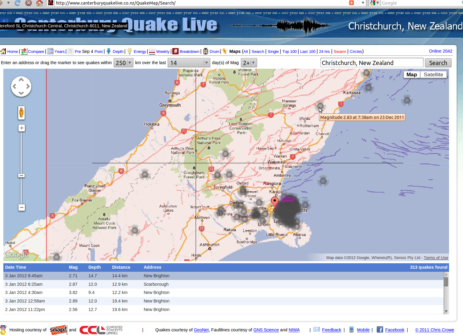 The spread of the stress load from the Greendale fault - onto the north-west to south-east 13 June 2011, Southshore to Pigeon Bay faultline and beyond - is clearly discernible in this close-up. Highlighted is the quake moment when energy fans north-east too, onto the Kaiapoi offshore faultline - pending more stress accumulation (after Pigeon Bay gives?): 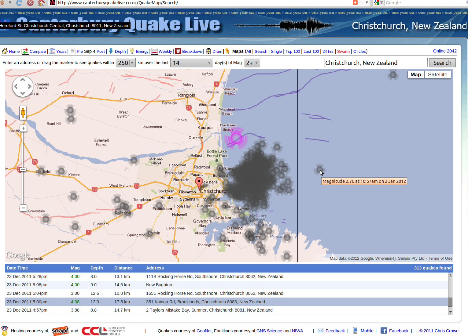 Source: canterburyquakelive.co.nz/QuakeMap/Search Another, longer view of the recent quake history: 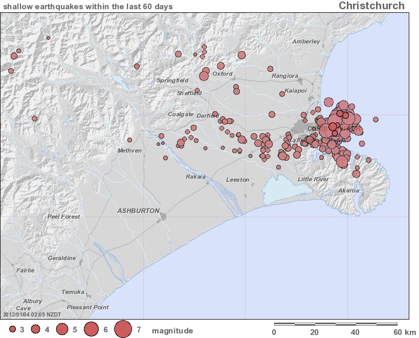 Source: geonet.org.nz/resources/earthquake/recent-regional-seismicity/shallow-seismicity Yikes! Today, 4/01/12 with aftershocks rife again off New Brighton, this chart is now looking worse/grumblier than it did BEFORE 23 December 2011: 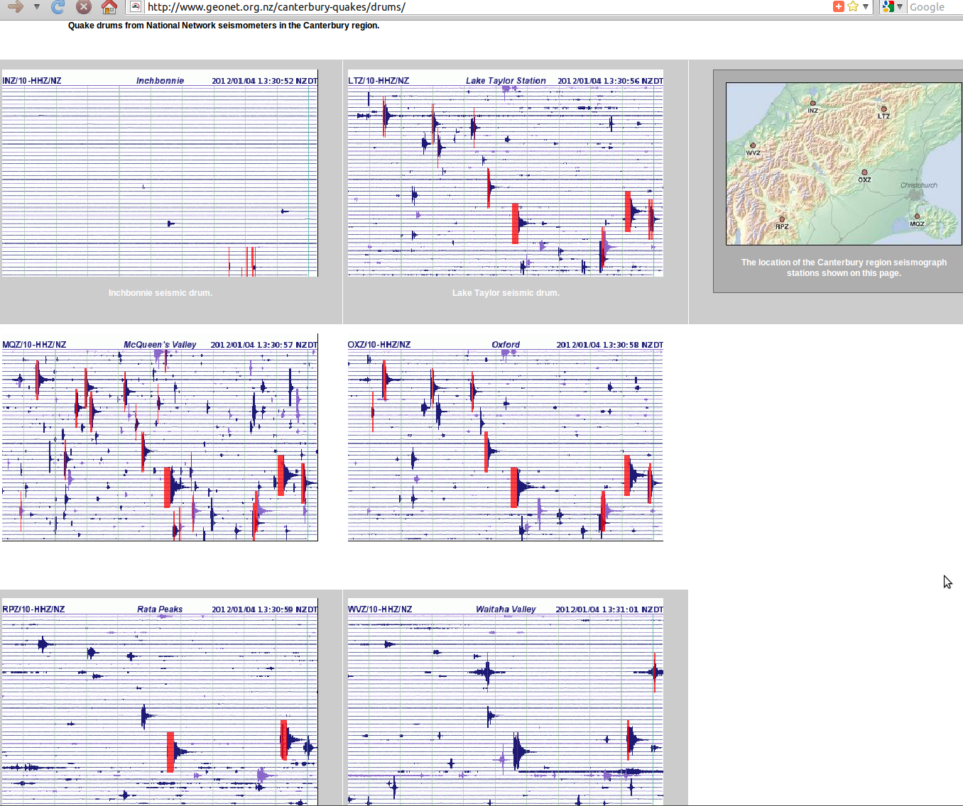 Canterbury's still on the move "..and settling in response to two years of earthquakes. High-precision readings from satellites show the land below Christchurch and the eastern Canterbury Plains is still deforming at an average rate of several millimetres a year. The land movement is not just a direct consequence of aftershocks but is known as 'post-seismic deformation', which could be due to slow fault-slip around the edges of the faults that ruptured in the main Canterbury quakes.." 05/09/2012 + Canterbury earthquakes broke the rules "Stress and pressure had been building up beneath Canterbury for thousands of years.. Christchurch experienced more aftershocks because of the nature of rock beneath the city. Christchurch sits on a brittle layer of fractured basalt and schist, topped by a thinner layer of greywacke.. Maybe in 3000 or 4000 years, we will have another one.. 'the system seems to be sorting itself out'." 04Oct12 Undersea fault line risk swells "GNS Science, along with the National Institute for Water and Atmospheric Research (Niwa), have just wrapped up a major project to revise the New Zealand National Seismic Hazard Model (NSHM). A number of newly identified faults have now been added to the model, raising the total number of known fault lines by about 200 - to nearly 530. Niwa said a particularly large fault found offshore near Canterbury had the potential to cause a significant tsunami.. in the bedrock under Pegasus Bay.. New Zealand had to prepare for marine quakes in many locations" 14/11/2012 + Fault off Kaiapoi may spark marine quake 'magnitude 6+ during next ~100,000 years' 15Nov12 Pressure building under Ruapehu "GNS vulcanologists were focusing their research more on the connection between slow earthquakes and volcanic activity" 19Nov12 "'The Temple for Christchurch' is a large scale interactive art installation that seeks to provide a mechanism for emotional healing alongside the physical rebuilding of the city, and to be a catalyst for reflection on the past two years of earthquakes; from the initial damage caused, the lingering effects, to the process of recovery, and residents' hopes for the future" templeforchristchurch.org 2012 + Sensing City .org "Christchurch as the only city in the world where people can understand how cities really work. Cities are complex places. Exactly how they function is not well understood. The ability to measure flows of information, traffic, water and other variables is now seen as fundamental to creating livable and sustainable cities" Trough could help probe big quakes "Hikurangi Trench, or subduction zone, lies less than 100km off the east coast of the North Island and runs south to offshore off Kaikoura.. and two similar trenches off the coast of North America and Alaska, would form the focus of a major global study of megathrust earthquakes, which can often be of magnitude 9.0 or higher and cause highly damaging tsunamis" The Press 28Jan13 Greater understanding of Alpine fault needed "A researcher says scientists need a greater understanding of the Alpine fault to help prepare for future earthquakes. University of Canterbury student Carolyn Boulton is finishing her PhD on the fault which forms the Australian-Pacific plate boundary on the South Island, which has not suffered a major quake for almost 400 years. 'Through my research, we have learned that the fault gets stronger with increasing temperature and pressure with increasing depth,' she said. 'We have also learned that when an earthquake occurs, the Alpine Fault's strength dramatically decreases.' Her research will not enable scientists to predict the timing of the next event but should help them understand the nature of the main-shock and aftershocks. Geological and Nuclear Sciences said there is a 30 percent chance of the next Alpine Fault earthquake occurring within 50 years." NZ Herald 15 Mar 2013 Aftershocks 'nothing alarming' "Aftershock activity has sparked up in the past week on each of the main faults responsible for Christchurch's recent major earthquakes.. 'It's still going on.. will be for some time. You could easily get another [mag] 5, but the probability is dropping all the time'" The Press 21May13 + 'Silent' quake gently rocks Wellington "huge underground movement called the Kapiti Slip.. occurring 40km beneath the Earth's surface, and stretches 100km between Kapiti and Marlborough. It's not a phenomenon unique to the area, or even New Zealand. 'It happens in four regions in the North Island of New Zealand, and it also happens at all the other subduction zones around the world like Japan and North America'.. A slow-slip quake happens in the Hawke's Bay and Gisborne every one-to-two years, at only 10 to 15km deep. GeoNet estimates around 40 percent of the North Island's tectonic plate movement occurs in slow slips" 3News 28May13 + New Zealand Is in the Midst of a Six-Month-Long Earthquake "a magnitude 7..'s been going on all year. It's the strongest earthquake to hit the region in 150 years" blogs.smithsonianmag.com/smartnews 290513 + "Slow-quake" shifts Gisborne 70mm to the east TVNZ 30Mar10 & 'Slow-slip' quake happening off Wellington "the Pacific and Australian plates had been slipping past each other since January and would continue for up to a year.. Apart from moving a few centimetres further away from Australia, there would be no noticeable impact from this seismic movement" 28May13 European-Mediterranean Seismological Centre Latest Earthquakes in the World etc EMSC-csem.org Live Earthquakes Map quakes.globalincidentmap.com Emergency and Disaster Information Service EDIS by Hungarian National Association of Radio Distress-Signalling and Infocommunications RSOE 21 Jul 2013 Wellington Quake Live .co.nz Latest Earthquakes Chris Crowe New quake faults found "New research has revealed that some of the West Coast is sandwiched between enormous offshore fault lines and the Alpine Fault. They are the type that generate tsunamis, which is bad news for coastal townships because it is unknown when they will rupture. National Institute of Water and Atmospheric Research (Niwa) scientists today released a report from a two-year mapping project for the West Coast Regional Council, which wanted to assess earthquake and tsunami risk for its coastal communities. The report identifies 10 active marine faults in a 320-kilometre stretch from Hokitika to Farewell Spit.." Fairfax 6Sep13 Strong crust cause of big Sth Island quakes "the layer of hard rock beneath Canterbury that caused some of the strongest earthquakes of their type recorded may extend as far as Oamaru.. rock body, from below the ocean, also occurred throughout Wellington and the East Cape, but was deeper below Canterbury. What was different about Canterbury's quakes was the rocks got stronger below 10km and continued to a depth of about 30km" The Press 27Nov13 + Quake research focus on Rangiora, Oxford "An earthquake faultline which passes directly through Oxford is the most active in the region, but scientists say its existence is not yet proven" 29Nov13 Tsunami risk in mega-quake zone "a tsunami from a quake east of New Zealand could take less than 15 minutes to reach the coast" radionz.co.nz 10Jan14 Scientists defend earthquake forecasting "mathematical models do not give specific locations or times for earthquakes, but rather the likelihood of a quake of a certain size during a given time period" 2Sep14 Scientists explain 2014 earthquake patterns in New Zealand "an unusually intense seismic period continues to affect New Zealand. The rate of quakes since 2009 has been more than double that of the previous few decades" 28Dec14 Major 6.0 earthquake west of Arthur's Pass nr Coleridge "not caused by Alpine Fault" The Press 6Jan15 Uncertainty how Friday's quake may affect Cook Strait faults Molesworth M6.2 "hesitant to say whether stress transfer from Friday's quake could reignite Canterbury's faults. 'But given Cook Strait has had a couple of decent rumbles lately, a couple of bigger ones might be coming there.'" The Press 26Apr15 Megaquake could hit central New Zealand "researchers have found solid geological evidence that an area off the coast of Wairarapa and fringing Cook Strait causes "megathrust" quakes and tsunami similar to, but probably smaller than, the devastating magnitude 9.0 March 2011 event in Japan.. highlights the active threat the southern Hikurangi margin - where the Pacific Plate is being dragged down below the Australian Plate - poses to life and livelihood from Hawke's Bay south to the Wairarapa, Wellington and Marlborough.. relatively short time interval between.. two events.. about 350 years" '~3m tsunami risk' Stuff 19 May 2015 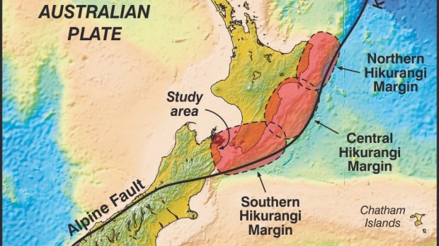 Simulation of a Magnitude 8.4 Megathrust Quake in New Zealand "Yoshihiro Kaneko shows how computer models of seismic waves and the associated tsunami from a plate boundary earthquake allow us to estimate the potential impacts.. work was funded by New Zealand's Natural Hazards Research Platform and public research funding from the Government of New Zealand" youtube.com GNS Science 12Nov15 Transition Breakthrough Facilitation "free service that allows you to have an independently facilitated conversation with your insurer where you set the agenda" BreakthroughServices.co.nz was CanCERN Magnitude 4.1 quake shakes Christchurch "within the region's expected post-2011 aftershock patterns, GNS Science says. The quake struck at 12.24pm on Thursday, putting workplaces across the region on edge as it approaches the fifth anniversary of the February 22, 2011, quake. It was centred 10 kilometres west of Christchurch, near the Shands Rd and Marshs Rd intersection between Templeton and Prebbleton, at a depth of 16km" The Press 28Jan16 + 'Light' earthquake rattles Wellington "4.1 magnitude earthquake has hit 30km south-west of Wellington at a depth of 50km.. 3.20pm, was felt by residents in the capital's CBD" radionz.co.nz 29Jan16 5.8-6.6 mag Earthquake shakes North Island radionz.co.nz 2Feb16 + Lack of offshore sensor led to quake confusion 3Feb16 & 'Ghost quakes' rattle alert system Christchurch hit by severe earthquake The Press 14Feb16 + Sumner cliff collapses in latest Chch quake & LIVE updates: Christchurch quake radionz.co.nz + Canterbury earthquakes moving east 'like a zip' The Press 15Feb16 + Christchurch earthquake: The story behind this dramatic photo NZ Herald 15Feb16 Why does Christchurch keep being hit by earthquakes? RNZ 15Feb16 EQNZ update: worst-case scenario New Zealand earthquake blog post 12May16 Christchurch Dilemmas "Films & conversations about the future of our city. An independent interactive documentary funded by New Zealand On Air and supported by Radio New Zealand" chchdilemmas.co.nz by Gerard Smyth Frank Film.co.nz + Episode one - The Red Zone RNZ 8Aug16 Brendon Bradley UC "Simulation of the 2016 Mw7.8 Kaikoura earthquake and response of buildings in Wellington" etc youtube.com/channel Young Engineer of the Year Finalist 2014 Kaikoura 7.8 mag 14Nov16 In the wake of the quake New Zealand Geographic & What Kaikoura taught us about Wellington nzgeo.com Kaikoura Earthquakes information GNS Science + NIWA's offshore mapping adds more faults to the latest Kaikoura fault rupture map 6Mar17 Kaikoura's 'complicated and unusual' earthquake could've broken world record "21 faults had surface rupture.. about 180 kilometres of fault surface throughout the Canterbury, Kaikoura and Marlborough regions, where in places, the ground has been offset by up to two metres vertically" TV1 News 15Mar17 + Kaikoura quake's 21 faults could be world record Radio NZ Kaikoura earthquake moved the South Island, new research shows "shunted parts of the South Island more than 5 metres closer to the North Island.. first major research derived from the earthquake.. [Science] said the earthquake's characteristics could not have been predicted by existing models.. at least 21 faults, some of them previously unknown, had ruptured across two active fault domains that were not known to be connected. The rupture took about two minutes to travel from its starting point near Culverden to its end point north of Kaikoura, 180 kilometres away.. up to 12 metres of horizontal displacement.. one of the most complicated plate boundaries in the world.. 'Some of the apparent jumps between faults I don't think any seismic hazards model in the world would have considered a possible scenario.' The plate boundary ruptured across two fault domains: the North Canterbury system and the Marlborough system. Scientists did not know they were connected.. paleoseismic studies - the analysis of earthquakes long ago, which are frequently used for hazard models - may not account for more complex ruptures.. you can end up with larger events than you might expect" The Press 24Mar17 & Kaikoura Earthquake tsunami was as high as 7 metres at one spot "highest at Goose Bay, and only slightly less high at Oaro Bay.. A main cause of the tsunami was thought to be rupture of the Hundalee Fault that extended offshore just north of Oaro. There was uplift where the fault ruptured on land of about 2m, and that would have continued offshore.. Underwater landslides.. appeared to have been smaller.. one of the most significant tsunami for probably half a century.. happened between low and mid-tide. That combined with the uplift of the land by 1-2m limited the damage caused.. Immediately after the earthquake the tide level at the Kaikoura tide gauge started dropping. Over 25 minutes it dropped about 2.5m, a classic warning sign of a tsunami. During the next 15 minutes the water level rose from its lowest level by about 4m. That was followed by a series of waves over several hours.. The water level at the Kaikoura gauge rose to 2.5m higher than it would have been. That was made up of a 1.5m rise measured on the gauge, and a rise of about 1m of the gauge itself, as the seabed and surrounding land rose by that amount. Some other tide gauges that recorded the tsunami were in Wellington Harbour, Castlepoint, Christchurch and the Chatham Islands. Tsunami height could be very localised and very influenced by the shape of the coastline.. At the V-shaped Little Pigeon Bay on the north side of Banks Peninsula, where a vacant cottage was inundated, the runup height was about 3m.. More details of the tsunami are expected to become available soon in a jointly authored study by GNS, NIWA and UNSW Australia" 28Mar17 & Flurry of light to weak earthquakes in Taupo zone a continuation of earlier swarm "Taupo is one of the most frequently active and productive caldera in the world.. large caldera volcanoes and geothermal systems and many small earthquakes.. zone is a rift area, growing wider by 6mm to 9mm each year. Volcanologist do not think swarms in the area are related to volcanoes in the zone" Stuff 29Mar17 & Taupo super-eruption secrets revealed "Between the two magma pools lay the Kaiapo fault, where the land on both sides was pulling away from each other. It was up this rifting fault the northeast-type magma travelled, below the surface, on a collision course with the caldera, before erupting at the Taupo vent.. To the observer, seeing small-scale eruptions, followed by lulls lasting months, it might have seemed the volcanic activity was not particularly dangerous. In reality, less than 0.1 per cent of the caldera magma had erupted. It was just a matter of time.. systems believed to be dormant" Dominion Post 21Apr12 Kaikoura Earthquake kick-started slow-slip event in upper South Island "The magnitude-7.8 November earthquake set in motion a slow-slip event under the upper South Island that has so far released the same amount of energy as a magnitude 7.3 earthquake. The plate boundary in the area, about 25 kilometres beneath the earth's surface, has slipped up to half a metre since the November 14 quake.. 'This movement was most active during the first month after the earthquake and has slowed down considerably since the start of the year'.. Hikurangi subduction plate boundary.. similar to slow-slip events in the North Island.. updating calculations on the likelihood of a quake of similar or greater size to the Kaikoura Earthquake within the next year. Current models suggested a 5 per cent chance of that happening. While that was small, it was about six times greater than before the Kaikoura event. Other slow slips set off by the Kaikoura quake and identified earlier were offshore from the east coast of the North Island and beneath Kapiti. The event offshore from the east coast - between Gisborne and southern Hawke's Bay - had stopped, after up to 15cm of movement that was mostly finished by the end of November.. It released energy equivalent to a magnitude 7.1 earthquake, and more than 200 nearby quakes were associated with it, including a magnitude 5.5 near Porangahau on November 22. The Kapiti event, which extended to the Marlborough Sounds, had slowed a little. Tectonic plates had moved past each other by several centimetres, with the energy released equivalent to a magnitude 7.0 quake. Based on previous Kapiti slow-slip events, it was expected to continue for at least a few more months" Stuff 30Mar17 Kaikoura discovers silver lining to November 14 earthquake "Kaikoura District Council is hoping it has saved millions in erosion control.. The magnitude-7.8 quake shunted much of Kaikoura's coastline upwards.. including a new surf spot for locals. Environment Canterbury (ECan) has been investigating coastal erosion since before the earthquake, and is collecting data on whether the land shift has helped solve the problem.. the issue mainly affected the coast directly in front of the township, and residents had been raising concerns with the council about high sea levels before the earthquake. 'It was becoming more regular and it was starting to erode the beach, and it was starting to undermine our infrastructure'" Stuff 19Apr17 Dunedin's closest active fault 'behaves strangely and the risk is hard to define' "potential earthquake hazard from the Akatore fault.. a worry when it comes to the risk to Dunedin residents & coastal Otago.. signs of three significant earthquakes.. in the past 12,000 years, following a long quiet spell possibly stretching back about 125,000 years.. estimated the three recent quakes had magnitudes of between 6.8 and 7.4, each quake rupturing the ground by up to two metres vertically.. The first major Akatore quake was sometime between 12,100 years ago and 1280 years ago. The second and third major quakes appear to have happened around 1,280 years ago and 760 years ago" Stuff 27Apr17 'We're entering a new phase of earthquakes in New Zealand' "Back in 2013, there were a number of fairly major quakes that spread across Wellington. This inspired Wellington-based author Matthew Wright to look back at New Zealand's history with earthquakes - the social, historical and scientific background - and where we stand with them today. The result is his new book, Living on Shaky Ground: The science and story behind New Zealand's earthquakes" RNZ 2Feb20 & How NZ would fare during a world catastrophe "public health experts warn there are even bigger threats out there that we should also be preparing for" 5Feb20 What we do during an earthquake & why it matters "sometimes doing nothing is a safer option than taking the wrong action" RNZ 20Feb20 |
| Page Sponsor detail completed here | |
Back to Sept 4 quake | government | InfoHelp home
|
Free |
Copyright © Canterbury Technology Ltd Edit version 5:30PM GMT+12 12/04/20 |